Megatrend · Space Economy
Satellites photograph the whole planet every day — but the money isn't in the "pictures"
Right now there are hundreds of tiny satellites, each the size of a shoebox, orbiting and photographing every square inch of the planet every 24 hours — day, night, through clouds. But here's what investors need to understand: selling raw images is a business whose price keeps falling. The real money has moved to the top layer: the AI that turns pixels into answers. How big the rice harvest will be, which ship cut its signal to smuggle oil, where a gas pipeline is leaking methane. This is the business of "intelligence from space," and its biggest customer is the military.
01What it is
Imagine one camera floating in the sky, photographing your house once a day, every day, all year — then lay the photos in a row, and you'll see everything that changes: trees growing, more cars parked, floods, new buildings going up. Now scale that one camera up into a swarm of hundreds of satellites photographing the whole planet, not just your house. That's Earth Observation.
Earth Observation (EO), or "observing the Earth," is the business of satellites that photograph and measure the planet's surface, then sell that data as a product. The term Geospatial Data means any data tied to "coordinates on a map" — satellite imagery is the starting raw material, but the thing that really sells for a high price is what comes after it.
On the megatrend map, this node is a sub-branch of Space Economy. Its definition is straightforward: "commercial imaging satellite constellations + monthly/yearly geospatial data and analytics products." The key word is recurring — not selling an image once and being done, but selling "continuous sight" as a long-term contract.
Optical = a camera that captures what our eyes see — beautiful, detailed, but useless at night, and done the moment a cloud blocks it · SAR (radar) = fires radio waves down and reads what bounces back, so it can "see" through clouds, through darkness, and even in the rain (hugely important for the military) · RF (radio signals) = takes no pictures, but listens in on radio waves from the surface — for example, catching a ship that turned off its transponder to smuggle cargo.
02Why it matters — a living map of the world
Satellite images used to be rare and very expensive — only governments or intelligence agencies had them, and getting an image of one area could take weeks. But now the cost of launching a satellite into orbit has fallen enormously (see Launch Services), and satellites have shrunk to the size of a shoebox. The result: private companies can launch satellites by the swarm, turning Earth imagery from a "rare still photo" into a "world map updated every day."
What's it worth? Think about it: if you could see everywhere on Earth every day, what would you know before anyone else? A cornfield in Brazil is drier than usual → grain prices will rise · a mall parking lot is fuller than last year → this quarter's sales are good · more oil tankers are sitting idle offshore → oil is starting to glut the market. This is why funds, hedge funds, insurers, and the military pay a premium for this kind of "sight."
The market picture reflects this clearly. The whole Geospatial Analytics market is worth around $114 billion in 2024 and is expected to grow to ~$227 billion by 2030 (CAGR ~11%), while the "image analytics layer" closest to EO keeps growing too.
But the number that best tells you "where the money is" is this one: the market for raw EO imagery from satellites was only about $4.3 billion in 2025 — nearly 3× smaller than the image-analytics market ($12.1 billion). In other words, for every $1 paid for the "raw image," several more dollars are paid for "interpreting the image."
03How it works (pixels → answers)
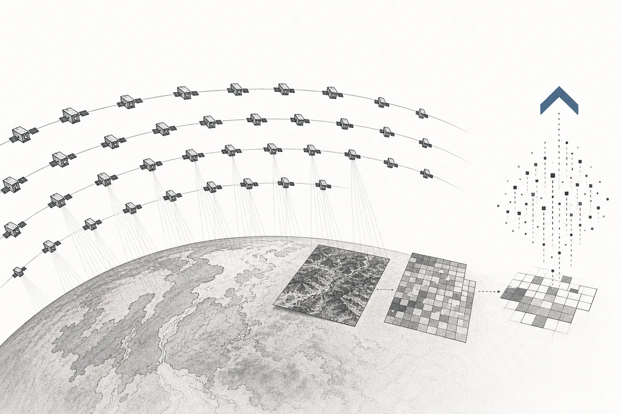
The heart of this lesson is understanding EO's "value production line" — why the money flows to the far end, not the near end. It has 4 stages, and at each one the product becomes "more expensive and harder to copy."
First stage: a swarm of hundreds of satellites (a constellation) orbits and photographs. Second stage: the raw images are beamed down to ground stations — but raw images alone are nearly worthless, because anyone with a swarm can capture the same thing (it's a "commodity"). Third stage: AI sweeps through enormous volumes of images and finds "what changed" — comparing day to day, counting cars, counting ships, catching leaking pipes. And the fourth stage — where the money is — turns what the AI sees into an "answer" the customer can act on immediately.
This is why the whole industry talks about the same thing: moving from "selling images per square kilometer" to "selling answers as a service" (insights-as-a-service). Because raw images can be captured by anyone and the price keeps dropping, but AI trained for a specialty — one that knows what a methane-leaking gas pipeline looks like, that knows how an illegal fishing boat moves — is what rivals find hard to copy.
The most concrete example in 2025 is when Planet Labs teamed up with Anthropic, feeding daily Earth imagery to the AI model Claude to automatically "read" for anomalies worldwide — going from needing an analyst to stare at images one sheet at a time, to AI sweeping the whole world in no time. This is the fourth layer, which is becoming the real battlefield.
04Where it sits in the Space Economy
EO is one of the seven sub-branches of Space Economy, and it's one of the branches that can "bring money back to Earth" fastest, because customers pay for data they can use right away — no need to wait a decade for the technology to ripen. Here's how it connects to its neighbors in the ecosystem:
- Sits on Launch Services: the falling cost of getting things into orbit is the reason hundreds-strong satellite swarms could exist in the first place
- Buys the satellites from Satellite Manufacturing: some EO companies build their own satellites (Planet, Satellogic), others buy from manufacturers — the bus and the camera/radar come from this branch
- Feeds Artificial Intelligence as raw material: daily Earth imagery is prime "food" for AI models — and in turn, AI is what makes raw images valuable. The two depend on each other
- Driven by Defense & Geopolitics: the world's tensions are the fuel of demand — the military and intelligence agencies are the biggest customers (see the next chapter)
- Reinforces Climate Adaptation & Water and Smart City: continuous imagery is the tool for watching floods, droughts, and forests, and for planning cities
Worth knowing: in our map, commercial EO sits in the Space Economy trend, while "pure military spy satellites" are split off to the Space Defense side. But in reality this boundary blurs every day, because private companies have already become the main suppliers to the military.
05Where things stand now + the players
Here's a fact many find surprising: even though everyone talks about a "huge commercial market," today the real money — about 80% of the whole EO industry's revenue — comes from the military and government, while the commercial market (agriculture, insurance, finance) is still just ~20%. This is "the EO paradox": companies raise money on the dream of a commercial market, but the ones actually paying are the Pentagon and the intelligence agencies.
Here's fresh evidence from 2025: Germany signed a contract to buy radar data from the private company ICEYE (together with Rheinmetall) worth €1.76 billion, and the U.S. imagery-intelligence agency (NGA) launched a program called "Luno" to hire private firms for AI image analysis — for example, having BlackSky do automated "change detection." Military demand is the real engine of the industry right now.
On the technology side, the game changed because of "frequency," not just "sharpness," anymore. Planet Labs has a swarm of over 200 Doves (each shoebox-sized) photographing the whole planet every 24 hours at about 3.7-meter resolution — the images aren't the sharpest, but "photographing every day" is the value. Meanwhile the high-resolution leader Maxar/Vantor focuses on images sharp enough to see individual cars, and the SAR (radar) side is growing fastest because it can "see" in any weather.
What's interesting is that many of the "real" players are still private companies not on the stock market — ICEYE (radar, Finland) and Capella (radar, U.S.) make revenue and sign billion-dollar military contracts, but haven't IPO'd yet. Maxar, meanwhile, was bought by the private equity firm Advent for $6.4 billion in 2023 (now renamed Vantor). So the players you can buy shares in directly are a select group — we've picked the standouts to walk through.
06The road ahead
The first direction, the clearest, is "going all the way up to the analytics layer." Every company knows selling raw images is a dead end, because the price only goes down. The goal is to own the "answer" a customer can pull up on a dashboard instantly — crop-yield forecasts for a whole continent, the ship count at every port, greenhouse-gas leaks from every source. The business model is shifting from "pay per square kilometer" to "subscribe to receive answers" (subscription).
The second direction is AI directly on the satellite (edge AI). Instead of beaming all the raw images down to process on the ground (which eats enormous bandwidth), the new generation of satellites "thinks" in orbit — spot a suspicious ship, and it sends down just an "alert," not the whole image, so it can respond in minutes.
The third direction is fusing multiple eyes. The future isn't optical or SAR or RF alone, but all three layered together: the camera sees there's a ship, the radar confirms it at night, the RF catches that it's gone dark — combined into a far more confident answer. And this is exactly what the military pays the most for.
07Challenges & risks
EO's appeal comes with risks you need to spot.
The first risk is "raw images are becoming cheap" (commoditization). When anyone can launch a swarm and capture images, the price per square kilometer keeps diving. Companies stuck only at the "selling images" layer, without a strong analytics layer, will see their profits squeezed hard — which is why everyone is racing up to the top layer, and those who can't keep up will get hurt.
The second risk is leaning too hard on government revenue. When ~80% of the money comes from the military and government, the whole industry's revenue is tied to defense budgets and politics. If budgets get cut, or a government decides to build its own satellites instead of buying from the private sector (a risk the industry genuinely worries about in the U.S.), a big chunk of demand can vanish — and the dream of a commercial market to replace it has been "slower to arrive than hoped" for years now.
The third risk is fierce, capital-heavy competition. This is a business that has to burn enormous money to build and replenish satellite swarms (satellites last only a few years before they fall and must be relaunched constantly). Many players are still losing money, and China is racing hard to build its own swarms, crowding the field and intensifying the price war — only those with an analytics layer as a moat and financial discipline will survive.
In short: Earth Observation is turning "images of the Earth" from a rare, expensive thing into a stream of data that flows every day. But the most important lesson is — the value has already moved from the "image" itself to "the meaning of the image." Whoever owns the AI that best turns pixels into answers owns the future of this industry.